6.4 magnitude quake shakes western Indonesia, no tsunami reported

29 August 2022
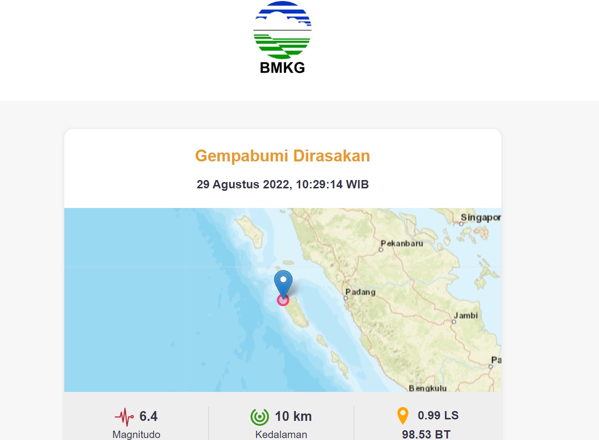
An earthquake with a magnitude of 6.4 shook the Mentawai Islands in Indonesia’s western province of West Sumatra, on Monday (August 29, 2022), at 10.29 a.m. local time. (BMKG)
The earthquake in western Indonesia was a shallow earthquake due to the subduction activity of the Mentawai-Siberut Megathrust segment plate.
Jakarta (Indonesia Window) – The Meteorology, Climatology and Geophysics Agency (BMKG) said that an earthquake with a magnitude of 6.4 shook the Mentawai Islands in Indonesia’s western province of West Sumatra, on Monday, at 10.29 a.m. local time.According to Daryono, Acting Head of the BMKG’s Earthquake and Mitigation Center, in his tweet on Twitter on Monday, there have been three earthquakes in the Mentawai-Siberut Megathrust Segment with magnitudes of 4.9, 5.8 and 6.1 in approximately 12 hours.The tectonic earthquake in western Indonesia did not have the potential for any tsunami, Daryono said, while calling on the public to remain calm and alert because of possible aftershocks.The result of the BMKG analysis shows that the earthquake has an update parameter with a magnitude of 6.1.The epicenter of the earthquake was located in the sea at a distance of 12 kilometers northwest of West Siberut, Mentawai Islands, West Sumatra, at a depth of 24 kilometers.The BMKG explained that the earthquake was a continuation of the earthquake activities that occurred earlier at 00.04 a.m. local time with a magnitude of 4.9 and at 5.34 a.m. local time with a magnitude of 5.8.The agency further said that the earthquake was a shallow earthquake due to the subduction activity of the Mentawai-Siberut Megathrust segment plate.The earthquake had an impact and was felt in the Siberut area (V-VI MMI/modified mercalli intensity), Tuapejat and Painan areas (III-IV MMI), Padang city (III MMI), Padang Panjang city, Bukit Tinggi city, Solok district and South Solok district (II-III MMI).The earthquake caused minor damage in the North Siberut sub district and West Siberut sub district. As of 11.20 a.m. local time, the BMKG monitoring results have not shown any aftershocks.Some local residents temporarily evacuated to an open air place. They are advised to remain calm and not be influenced by issues that cannot be justified.On Oct. 25, 2010, at 9.09 p.m. local time, an earthquake with a magnitude of 7.7 rocked the Mentawai Islands, West Sumatra province.Data from the United States Geological Survey (USGS) showed that the earthquake was centered off the southwest coast of Pagai Island, at a depth of 20.6 kilometers under the seabed.This shallow earthquake triggered a tsunami along the coast of the Sipora Islands, North Pagai, and South Pagai in Mentawai.The earthquake killed 448 people and damaged public facilities and houses, according to data from Indonesia’s National Disaster Management Agency (BNPB).Reporting by Indonesia WindowBagikan

Komentar
Berita Terkait

Indonesia again offers free work and health safety training for 2,100 participants.
Indonesia
•
06 Apr 2026

Indonesia calls for developing sustainable marine economy
Indonesia
•
07 Dec 2022
Health aspect moves regional economy: RI’s president
Indonesia
•
12 Nov 2020

Feature – Taiwan leading in semiconductor technology
Indonesia
•
10 Dec 2023


Berita Terbaru

Profile – Indonesian Islamic boarding school student discovers security flaws in systems of NASA, University of Melbourne
Indonesia
•
17 Sep 2026

Suahasil Nazara Indonesia’s new finance minister, replacing Purbaya
Indonesia
•
14 Sep 2026

Indonesia’s professor: ‘Dhikr’ in Islam not merely verbal utterance, but matter of awareness and conduct
Indonesia
•
14 Sep 2026

Minister: Airports affected by Mount Anak Krakatau volcanic ash reopen
Indonesia
•
08 Sep 2026